Hurricane forecast update: Tropical Storm Hermine 2016 path, storm surge forecasts
Published 7:05 am Thursday, September 1, 2016
Tropical Storm Hermine is getting stronger and by the overnight hours tonight Hurricane Hermine 2016 is expected to strike the Florida western coast as a category 1 storm,
No hurricane has made landfall on Florida in a decade.
Here is the latest forecast update, path prediction and storm surge prediction for Tropical Storm and soon-to-be Hurricane Hermine 2016 from the National Hurricane Center:
Hurricane conditions are expected to reach the coast within the warning area beginning tonight. Winds are expected to first reach tropical storm strength by this afternoon, making outside preparations difficult or dangerous. Preparations to protect life and property should be rushed to completion. Tropical storm conditions are expected to begin within the warning area along the Atlantic coast on Friday.
Tropical storm conditions are possible in the tropical storm watch area by Friday night and Saturday.
STORM SURGE: The combination of a dangerous storm surge and the tide will cause normally dry areas near the coast to be flooded by rising waters moving inland from the shoreline. There is a danger of life-threatening inundation within the next 36 hours along the Gulf coast of Florida from Aripeka to Indian Pass. For a depiction of areas at risk, please see the Prototype National Weather Service Storm Surge Watch/Warning Graphic.
Persons located within these areas should take all necessary actions to protect life and property from rising water. Promptly follow any instructions, including evacuation orders, from local officials.
The water could reach the following heights above ground if the peak surge occurs at the time of high tide…
Destin to Indian Pass…1 to 3 feet
Indian Pass to Chassahowitzka…4 to 7 feet
Chassahowitzka to Aripeka…2 to 4 feet
Aripeka to Bonita Beach…including Tampa Bay…1 to 3 feet
Florida-Georgia line to Cape Fear…1 to 3 feet
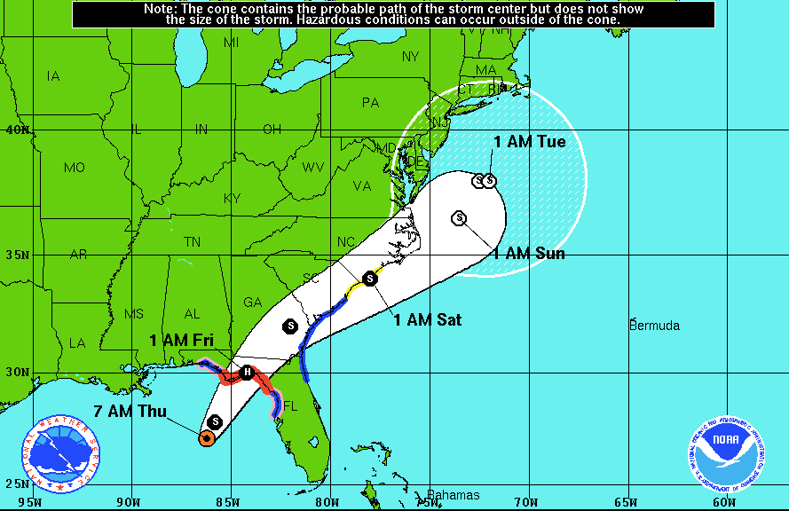
Hermine is expected to strike Florida overnight tonight as Hurricane Hermine 2016, a category 1 storm.
The Prototype National Weather Service Storm Surge Watch/Warning
Graphic is a depiction of areas that would qualify for inclusion
under a storm surge watch or warning currently under development by
the National Weather Service and planned for operational use in
- This prototype graphic is available at
www.hurricanes.gov/graphics_at4.shtml?wsurge
RAINFALL: Hermine is expected to produce storm total rainfall
accumulations of 5 to 10 inches over portions of northwest Florida
and southern Georgia through Friday, with possible isolated maximum
amounts of 20 inches. On Friday and Saturday, Hermine is expected to
produce totals of 4 to 8 inches with local amounts of 10 inches
possible across portions of eastern Georgia, South Carolina, and
eastern North Carolina through Saturday. These rains may cause
life-threatening flash flooding.
TORNADOES: A few tornadoes are possible this afternoon into Friday
morning over north Florida and southeast Georgia. The tornado risk
will continue across the eastern Carolinas from Friday morning into
Friday night.
More TRENDING NEWS


-
-
-
Polls
 Loading ...