Hurricane Hermine 2016 damage updates: 22 inches of rain dumped near Tampa
Published 5:58 am Friday, September 2, 2016
CARRABELLE, Fla. (AP) — The Latest on Hermine (all times local):
6:45 a.m.
Outer bands from Tropical Storm Hermine continue to dump large amounts of rain across the Tampa Bay area.
Meteorologist Daniel Noah of the National Weather Service in Tampa says the rain should start slowing by Friday afternoon.
But the rain caused flooding in many areas of Tampa, St. Petersburg and coastal regions in Pinellas and Pasco counties. Law enforcement authorities are warning people to be extremely cautious while driving due to flooded roads and possible downed trees and power lines.
Noah says that over the past 72 hours, the Tampa Bay area has seen sign significant rainfall. An area west of Oldsmar in Pinellas County recorded 22.36 inches of rain while in nearby Largo some 15.23 inches of rain has fallen. Other rain totals include 10.73 inches in Seminole, 9.71 inches in Longboat Key and 8.61 inches in Port Richey.
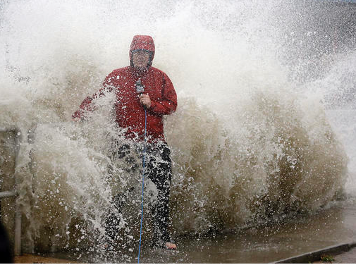
Hermine dumped 22 inches of rain near Tampa.
____
6:30 a.m.
Georgia Power reports that more than 30,000 of its customers were without power shortly before dawn Friday as Hermine rolls across the southern section of the state.
Georgia Power’s online outage map showed that many of the outages were in and around the cities of Valdosta and Brunswick.
In the Valdosta area, Lowndes County spokeswoman Paige Dukes said crews were dealing with fallen trees and snapped power lines, but no injuries had been reported. She says winds exceeding 55 mph had been recorded in the county, with 4 to 5 inches of rainfall.
Hermine was moving north-northeast across south Georgia at 14 mph toward Savannah on the coast.
___
6 a.m.
A couple suffered minor injuries during Hurricane Hermine when they drove into a downed tree along the coast of the Florida Panhandle.
Wakulla County Administrator Dustin Hinkel said Friday that the couple was driving during the storm and drove into a tree that had fallen into the road.
He said storm surge of 8 to 10 feet hit the county’s beaches, damaging docks and flooding coastal roads in the county that’s south of Tallahassee.
___
5:25 a.m.
Authorities in Florida’s Pasco County say coastal flooding has forced at least 18 people from their homes in Green Key and Hudson Beach as rain from Hermine drenches the state.
Early Friday morning, Pasco County Fire Rescue and sheriff’s deputies used high-water vehicles to rescue people from rising water. They were taken to a nearby shelter.
The sheriff’s office said in a news release that storm surge from the Gulf of Mexico, combined with intermittent bands of heavy rain, pushed water into low-lying neighborhoods.
Many roads in the area north of Tampa, are also flooded.
___
4:50 a.m.
Hermine has weakened to a tropical storm as it moves farther inland after making landfall in Florida’s Big Bend area as a hurricane.
The U.S. National Hurricane Center says the storm’s maximum sustained winds have decreased to near 70 mph with additional weakening forecast.
The storm is centered about 20 miles west of Valdosta, Georgia, and is moving north-northeast near 14 mph.
Hermine was the first hurricane to hit Florida in more than a decade when it came ashore early Friday.
After pushing into Georgia, Hermine is expected to move into the Carolinas and up the East Coast with the potential for drenching rain and deadly flooding.
___
4 a.m.
The U.S. National Hurricane Center says Hurricane Hermine is weakening as it moves into southern Georgia.
As of 4 a.m. EDT, the storm is centered about 35 miles west-southwest of Valdosta, Georgia, and is moving north-northeast at 14 mph. It’s maximum sustained winds have decreased to near 75 mph.
Hermine was the first hurricane to hit Florida in more than a decade when it came ashore early Friday in the state’s Big Bend area.
After pushing into Georgia, Hermine is expected to move into the Carolinas and up the East Coast with the potential for drenching rain and deadly flooding.
___
3:35 a.m.
Hurricane Hermine is moving inland over the eastern Florida Panhandle after making landfall in the state’s Big Bend area Friday morning.
As of 3 a.m. EDT, the storm’s center was about 25 miles east of Tallahassee and it was moving north-northeast near 14 mph.
It’s the first hurricane to directly strike the Sunshine State in more than a decade, roaring in from the northwest Gulf Coast with 80-mph winds and heavy rains.
Hermine is expected to drop back down to a tropical storm before pushing into Georgia, the Carolinas and up the East Coast with the potential for drenching rain and deadly flooding.
___
1:55 a.m.
Forecasters say Hurricane Hermine has made landfall over northwest Florida just east of St. Marks.
It’s the first hurricane to directly strike the Sunshine State in more than a decade, roaring in from the northwest Gulf Coast with 80-mph winds and heavy rains.
The U.S. National Hurricane Center says Hermine made landfall early Friday around 1:30 a.m. EDT.
Projected storm surges of up to 12 feet menaced the coastline and expected rainfall up to 10 inches carried the danger of flooding through the storm’s path, including the state capital, Tallahassee, which hadn’t been hit by a hurricane since Kate in 1985.
Hermine is expected to drop back down to a tropical storm before pushing into Georgia, the Carolinas and up the East Coast with the potential for drenching rain and deadly flooding.
More TRENDING NEWS


-
-
-
Polls
 Loading ...