New signs to help keep visitors moving
Published 8:00 am Thursday, February 8, 2018
Visitors to Oxford will soon find it easier to get around town and find all of the places that make Oxford a town that draws thousands of tourists throughout the year.
The Oxford Board of Aldermen adopted a new Wayfinding Master Plan Tuesday – a 70-page document that has been worked on for almost two years by the city of Oxford and its tourism and visitor center Visit Oxford, who contracted with Civil-Link and Arnett Muldrow & Associates to develop the master plan.
The primary goal of the Wayfinding Plan is to continue to pursue and expand tourism and economic development within Oxford by maximizing the experience of existing visitors.
The overall objective includes boosting visitor engagement with local attractions, improving visitor involvement that encourages longer or future visits and promote public safety by providing directional signage to vehicular and pedestrian traffic, streamlining routes to mitigate traffic congestion, maximize utilization of public parking areas inside the historic areas of Oxford and the Downtown Square, as well as improve aesthetics by having consistent signage throughout the city.
The city formed a steering committee made up of Mayor Robyn Tannehill, Visit Oxford Director Mary Allyn Hedges; Visit Oxford Deputy Director Kinney Ferris; Mark Levy with the Public Works Department; and Ben Requet, senior planner for the city of Oxford.
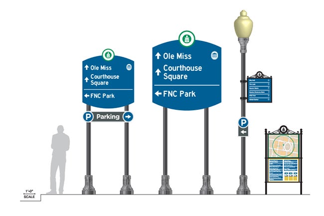
The plan focuses on five types of new signage:
- Vehicular directional signs, which help direct visitors to top local destinations along roadway corridors while also promoting safety and mitigating traffic congestion and will vary in size based on the existing speed limit along roadways.
- Pedestrian directional signs, which will be utilized to direct people to significant public destinations with the Historic Courthouse Square District, which is the city’s main attraction for visitors and tourists.
- Parking directional signs that will direct visitors to public parking areas.
- Walking maps to direct foot traffic around the downtown area and encourage visitor participation to local attractions. The signs will have a map with a point marked “You are here” and a list of notable attractions and businesses.
- Monumental primary gateways located at primary entrance points to the historic downtown area that will be large and built with brick or stone and possibility illuminated.
The Mississippi Hills Heritage Area Alliance awarded Oxford a $20,000 grant that will go toward the Wayfinding plan as well as the necessary signage. Visit Oxford has an additional $50,000 budgeted this year to begin the implementation of phase 1 of the signage plan.
“The signs are crucial to visitor satisfaction and will increase visibility to our attractions and other destinations around Oxford and the University of Mississippi,” Hedges said. “We want to make it as easy as possible for the visitor to find their destination and by having proper signage, it increases awareness of attractions and other destinations within the wayfinding plan.”
Mark Levy, with the Public Works Department, said the city will be soon taking quotes from different sign fabricators.
“We will be doing it in phases,” he said. “But we hope to get phase one done within the next three months.”
Levy said the designs for the signs will be before Oxford’s two historic preservation commissions – the Oxford Historic Downtown Preservation Commission and the Courthouse Square Historic Preservation Commission later this month for their approval of the signs and their placement.
An executive summary of the plan is available to view online here or by calling the Public Works Department at 662-232-2306.
More News


-
-
-
Polls
 Loading ...