Lafayette County to experience enhanced risks of severe weather
Published 10:21 am Wednesday, December 29, 2021
Several southern states are at risk of tornadoes, large hail and high winds as severe storms fire up over the region.
Northern portions of Alabama and Mississippi and parts of Tennessee will have an enhanced risk of damaging weather in Wednesday’s storms, forecasters said.
Tornadoes, damaging thunderstorm gusts and isolated large hail are possible from parts of the lower Mississippi Valley into the Tennessee Valley and southern Appalachians vicinity through tonight.
“A few tornadic supercells are possible, along with sporadic damaging gusts and isolated severe hail,” the Storm Prediction Center said in its storm outlook for Wednesday.
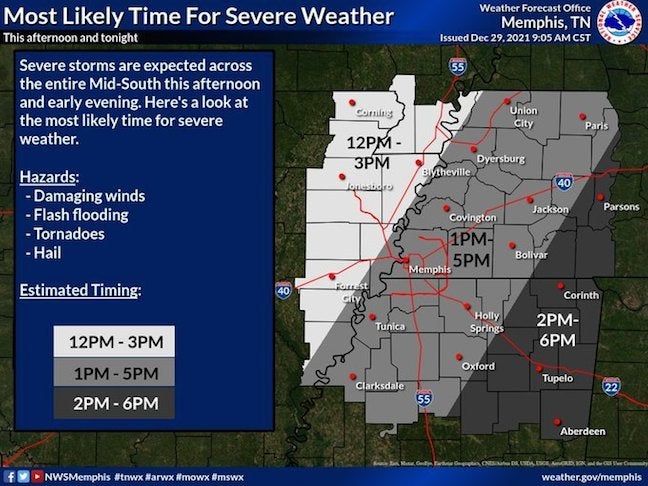
The most likely time frame for severe weather in the northwest region of Mississippi, including Clarksdale, Tunica, Holly Springs and Oxford, is from 1 to 5 PM. The northeast regions, in places such as Tupelo, Corinth and Aberdeen, will most likely experience severe weather from 2 to 6 PM.
According to the Memphis National Weather Service, northern Mississippi has a larger timing window than areas west of the Mississippi River due to the potential for isolated severe thunderstorms ahead of main clusters.
The risk of severe weather on Wednesday also extends into parts of Arkansas, Louisiana, Georgia and the Carolinas, according to the Storm Prediction Center.
Residents are advised to stay aware of the weather and have multiple ways to receive alerts.
More News


-
-
-
Polls
 Loading ...