Severe storms expected across Mid-South, main line could contain tornado
Published 10:00 am Thursday, February 17, 2022
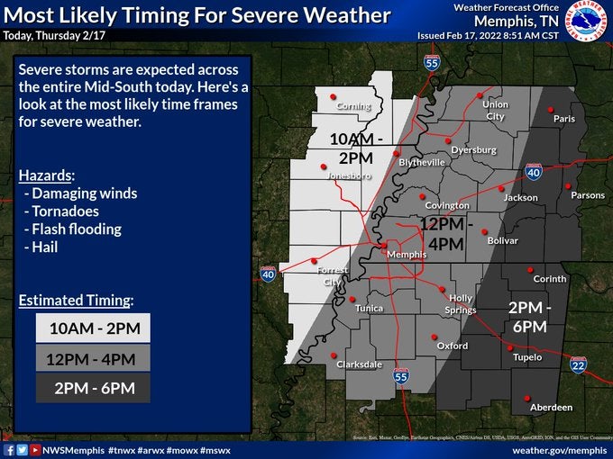
- (Photo: National Weather Service Memphis)
National Weather Service reports that severe storms are expected across the entire Mid-South today remaining at an enhanced risk. Majority of Lafayette County should expect to experience weather hazards such as damaging winds, tornadoes, flash flooding and hail from 12 to 4 PM. A small, southeast portion of Lafayette County could experience those same hazards from 2 to 6 PM.
Weather forecasters watched for any instability closely. If widespread showers continue throughout the morning through the evening, it would limit instability and decrease severe weather potential.
If there is less shower activity and breaks in the clouds, it would result in greater instability and increase severe weather risks.
Isolated showers and thunderstorms lined up during the morning but a more organized line will take shape west of the Mississippi River around noon, according to the NWS.
Strong winds will continue from Tuesday towards the south from 20 to 30 miles per hour with gusts up to 40-50. This will result in hazardous driving conditions and scattered power outages likely from weakened trees from previous ice storms.
Profile vehicles like trucks and SUVs or drivers headed along an east-west oriented roadway are advised to use caution on the road.
It is reported that conditions will improve from east to west late Tuesday afternoon and evening and winds will diminish overnight.
It is requested that individuals stay aware or the weather and have multiple ways to receive weather reports/warnings.
For information on how to prepare for a tornado or other severe weather, visit Lafayette County’s Emergency Management website at ema.lafayettems.com/be-prepared/tornado/.
Find your local storm shelters listed on the site at ema.lafayettems.com/be-prepared/.
More Top Home


-
-
-
Polls
 Loading ...