Wet, windy weather expected from Hurricane Irma remnants
Published 8:56 am Monday, September 11, 2017
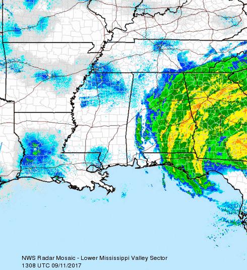
As remnants of what was Hurricane Irma make their way northwest, the LOU community is expected to get some rain and gusty winds.
Oxford Emergency Management Coordinator Jimmy Allgood said the tropical depression should make its way into Oxford this evening bring 1 to 2 inches of rain and wind gusts of about 30 to 40 mph.
The good news, he said, severe weather is not in the forecast.
“We should get any tornadoes or severe thunderstorms,” he said. “It’s mostly a rain event with some gusty winds.”
Allgood said residents should make sure garbage cans and outdoor furniture are secured since the gusts can reach 40 mph.
“If we get the heavier side of the predicted rainfall and some pretty good gusts, our biggest concern will be trees falling,” he said this morning.
There’s an 80 percent chance of rain tonight and a 90 percent chance of rain Wednesday.
“The rain should clear up by Wednesday night,” Allgood said.
The highs for Tuesday and Wednesday are in the late 60s with lows in the mid-50s. Thursday is forecasted to be sunny and clear with a high of 82.
Headed to help
Crews with North East Mississippi Electric Power Association were expected to leave out from Oxford Tuesday morning to drive to Florida to help restore power to those affected by Hurricane Irma when she slammed into south Florida Sunday morning.
However,
NEMEPA General Manager Keith Hayward said the 14 workers planning to go to Florida are being held in Oxford until sometime Wednesday due to the possibility of downed power lines in Lafayette County tonight and Tuesday.
Hayward said his crews were assigned to go to Lake Placid; however, he said that could change because of the delay.
“There’s nowhere to stop from here to there so it’s going to be a hard ride for them once they do leave,” Hayward said.
More News


SportsPlus
Cardinals vs. Nationals: Betting Preview for July 27
Alec Burleson and the St. Louis Cardinals (53-50) will host C.J. Abrams and the Washington Nationals (48-56) at…
How to Watch MLB Baseball on Saturday, July 27: TV Channel, Live Streaming, Start Times
Today’s MLB schedule features plenty of excitement, including the matchup between the Cleveland Guardians and the Philadelphia Phillies.…
Cardinals vs. Nationals: Betting Preview for July 26
The St. Louis Cardinals (53-49) and the Washington Nationals (47-56) will square off in the series opener on…
How to Watch MLB Baseball on Friday, July 26: TV Channel, Live Streaming, Start Times
There is no shortage of excitement on today’s MLB schedule, including the Cleveland Guardians squaring off against the…
How to Watch the Cardinals vs. Nationals Game: Streaming & TV Channel Info for July 26
Nolan Arenado and the St. Louis Cardinals hit the field against Juan Yepez and the Washington Nationals on…
-
-
-
Polls
 Loading ...