Lafayette County under Moderate Risk of Severe Weather for Wednesday
Published 11:17 am Tuesday, March 29, 2022
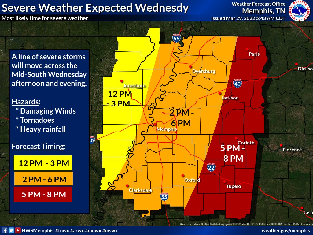
A cold front will bring in severe thunderstorms on Wednesday afternoon and evening. Damaging wind, heavy rain with flash flooding and a few tornadoes will be possible. The best estimate for the timing of the worst severe weather for Lafayette County is between 2 p.m. and 6 p.m. Wednesday.
Heavy rainfall is a possibility with predictions averaging from 1 to 2 inches of precipitation. Lafayette County and other north Mississippi areas are at a marginal risk for excessive rainfall with localized flooding primarily in areas that experience rapid runoff with heavy rainfall.
A Wind Advisory is in effect on Wednesday from 7 a.m. to 7 p.m. Strong winds sustained around 25 miles per hour with possible wind gusts up to 50 mph.
According to the National Weather Service, the storm mode looks to be more linear which means a line of storms with embedded quick spin-up tornadoes are possible along with the possibility of a stronger tornado.
More News


SportsPlus
Clemson vs. Memphis Predictions & Picks: Spread, Total – December 14
Saturday’s game between the No. 16 Clemson Tigers (9-1) and the Memphis Tigers (7-2) at Littlejohn Coliseum has…
How to Pick the Avalanche vs. Predators Game with Odds, Spread, Betting Line and Stats – December 14
Seeking best bets for the upcoming game between the Colorado Avalanche and the Nashville Predators on Saturday at…
How to Watch AAC College Basketball Games – Saturday, December 14
Friday’s college basketball slate includes one game with AAC teams on the court. That matchup? The North Dakota…
Grizzlies vs. Raptors Tickets Available – Thursday, Dec. 26
The Memphis Grizzlies (17-8) clash with the Toronto Raptors (7-19) at 8:00 PM ET on Thursday, December 26,…
College Basketball Picks Against the Spread: AAC Games Today, December 13
In one of the exciting matchups on the AAC college basketball slate on Friday, the North Dakota Fightin’…
-
-
-
Polls
 Loading ...