UPDATED: NWS Issues Severe Storm Warning for Lafayette County
Published 3:34 pm Saturday, December 9, 2023
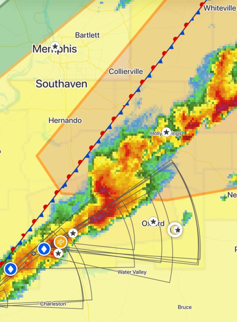
- NWS radar at approximately 3:50 pm CST
UPDATE: According to The National Weather Service, the Severe Thunderstorm Storm that resulted in the original Severe Thunder Storm Warning has moved from the area and that warning will expire at 4:15 pm as expected. Lafayette County remains under additional thunderstorm warnings that will go on until at least 5:00 pm. Storm systems will continue to move through the area throughout the evening with the severe weather threat to be gone by 10:00 pm.
UPDATE:
Separate cells are behind at least 3 active thunderstorm warnings for Lafayette County expected to arrive and end at different times according to National Weather Service. One warning ends at 4:15 pm, another at 4:30 pm, and another at 4:45 pm.
UPDATE:
The National Weather Service in Memphis has announced an additional severe thunderstorm warning lasting until 4:45 p.m. today. This warning includes southwestern Lafayette County, Yalobusha County, northern Tallahatchie County, southern Quitman County, and southeastern Panola County in northwestern Mississippi.
The storm, as of 3:52 p.m., was near Vance, approximately 13 miles west of Charleston, and is moving eastward at 50 mph. Hazards identified include ping pong ball-sized hail and 60 mph wind gusts.
The potential impact of the storm is significant, with the likelihood of injuries to people and animals outdoors, and damage to roofs, siding, windows, vehicles, and trees.
Impacted areas include Water Valley, Charleston, George Payne State Park, Coffeeville, Crowder, Webb, and several other nearby locations. For protection, it is advised to seek shelter in an interior room on the lowest floor of a building. A tornado watch also remains in effect until 7:00 p.m. CST for the region. Stay alert and follow safety precautions.
UPDATE: SECOND WARNING
The National Weather Service in Memphis has declared a severe thunderstorm warning effective until 4:30 p.m. today. This alert specifically targets Lafayette County and southern Panola County in northwestern Mississippi.
As of 3:46 p.m., a severe thunderstorm was reported over Batesville, moving east at a speed of 45 mph. The storm poses significant hazards, including ping pong ball-sized hail and 60 mph wind gusts.
The impacts of this storm are considerable, with potential injuries to people and animals outdoors. Expect damage to roofs, siding, windows, vehicles, and trees due to hail and wind.
Areas likely to be affected include Oxford, Batesville, Water Valley, and several locations within and around Holly Springs National Forest. Residents are advised to take cover in interior rooms on the lowest floors of buildings for safety. Additionally, a tornado watch remains active for northwestern Mississippi until 7:00 p.m. CST. Stay alert and follow safety guidelines.
UPDATE:
The National Weather Service reports that the severe thunderstorm warning will continue until 4:15 p.m. today for northwestern Lafayette, southwestern Marshall, southeastern Tate, and Panola Counties. As of 3:40 p.m., the storm was located over John W Kyle State Park, moving east at 50 mph.
This storm is particularly destructive for Panola and Lafayette Counties. It carries the risk of baseball-sized hail and 60 mph wind gusts. Radar has confirmed these conditions.
The expected impact is significant, with potential for severe injuries to those outdoors, as well as extensive damage to windows, roofs, siding, and vehicles. Areas at risk include Oxford, Batesville, and various locations within Holly Springs National Forest.
Residents are advised to seek shelter in the most protected interior rooms on the lowest floors of buildings. Additionally, a tornado watch is in effect for the region until 7:00 p.m. CST. Stay informed and prioritize safety.
The National Weather Service in Memphis has issued a severe thunderstorm warning effective until 4:15 p.m. today. Northwestern Mississippi regions, including parts of Lafayette, Marshall, Tate, and Panola counties, are under alert. The storm, detected near Batesville and moving eastward at 50 mph, brings risks of hail the size of ping pong balls and 60 mph wind gusts.
The warning highlights potential injuries to people and animals outdoors, with expected damage to buildings and vehicles. Areas such as Oxford, Batesville, Holly Springs National Forest, and several other nearby locations are directly impacted.
Residents are advised to seek immediate shelter, especially in interior rooms on the lowest floor of a building. Additionally, a tornado watch is in place for the region until 7:00 p.m. CST. Stay updated and exercise caution.
More News


SportsPlus
How to Watch SEC College Basketball Games – Monday, November 25
The Monday college basketball slate includes three games featuring an SEC team in action. Among those games is…
How to Watch Ole Miss vs. Boston College Women’s Basketball on TV or Live Stream – November 25
The Ole Miss Rebels (3-1) will attempt to build on a three-game winning run when they visit the…
How to Watch Boston College vs. Ole Miss Women’s Basketball on TV or Live Stream – November 25
The Boston College Eagles (6-1) will try to continue a three-game win run when they host the Ole…
Buy Tickets for New Jersey Devils vs. Nashville Predators on November 25
Two of the top players to keep an eye on when the New Jersey Devils face the Nashville…
Wizards vs. Grizzlies Tickets Available – Sunday, Dec. 8
On Sunday, December 8, 2024, the Washington Wizards (2-13) play the Memphis Grizzlies (10-7) at 7:00 PM ET…
-
-
-
Polls
 Loading ...