Severe weather possible Tuesday as cold front approaches
Published 7:59 am Monday, April 1, 2024
After a warm yet cloudy day today, another cold front will head into our area overnight, potentially ushering in some severe storms on Tuesday.
The high for today is expected to reach 80 degrees under mostly cloudy skies.
There is a slight chance for some showers between 3 and 4 a.m. Tuesday, with winds from the south picking up to 10 to 15 mph.
The chance of showers and thunderstorms increases to 80 percent later Tuesday morning. The high is expected to be around 78 degrees, dropping to a low of 45 Tuesday night.
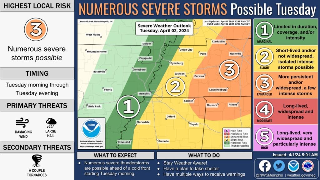
Lafayette County currently is listed as a 2 on a 1 to 5 severe weather risk rating scale by the National Weather Service, with 1 being the lowest risk and 5 being the greatest risk.
The storms could last throughout the day. Damaging winds and large hail are the primary threats, with a secondary threat of possible tornadoes.
Showers and thunderstorms could persist into the evening hours; however, by Wednesday morning the rain should move out of our area, leaving Wednesday with a high of 60 under sunny skies and breezing, with winds 10 to 20 mph and gusts as high as 30 mph. The low for Wednesday is expected to be 39 degrees.
Thursday and Friday should be sunny days, with highs around 60 to 64 degrees and lows in the mid-to-upper 30s.
Temperatures will slowly increase over the weekend, with a high on Saturday of 69 degrees and a low of 44 degrees and Sunday’s high is expected to reach 74 degrees. No rain is currently expected over the weekend.
More News


SportsPlus
How to Watch SEC College Basketball Games – Tuesday, December 10
The Tuesday college basketball schedule includes two games with an SEC team in action. Among those games is…
How to Watch AAC College Basketball Games – Tuesday, December 10
The Jacksonville Dolphins and the Florida Atlantic Owls square off in one of three games on the college…
Lions, Bills, Week 15 NFL Power Rankings
Who is the team to beat at the top of the league going into Week 15 of the…
Buy Tickets for Nashville Predators vs. Calgary Flames on December 10
The Nashville Predators’ Ryan O’Reilly and the Calgary Flames’ MacKenzie Weegar will be two of the top players…
Discover the Best Week 15 NFL Player Prop Bets & Odds
The Week 15 NFL schedule includes top teams in play. Among those contests is the Buffalo Bills taking…
-
-
-
Polls
 Loading ...